
 2.1 miles long, this is the gold standard of bicycle lanes of Bay Ridge and possibly one of the best on-street bicycle lanes in NYC. It extends from Owl's Head Park to John Paul Jones Park (aka Cannonball Park) at the base of the Verrazano Narrows Bridge. It parallels an uninterrupted length of park space along the harbor and offers views to the water along its gently rolling grades.
The far ends of the bicycle lane provide access to the harbor bicycle path at 69th Street and the end of 4th Avenue. Riding southbound, no cross streets intersect this route.
When was the bicycle lane painted along Shore Road? I don't know for certain but I think it was in place when we moved to Bay Ridge in 1996, or added soon afterward.
 For several years, the yellow traffic dividing line split the roadway equally, so the southbound traffic lane (12') and southbound bicycle lane (5') shared the same 17' dimension as the northbound 17' traffic lane. A realignment of the roadway striping happened around 2003 which resolved the dimensional inequalities. So today, most of the 50' curb-to-curb dimension of Shore Road has 1) an 8' parking lane, 2) a 14.5' northbound traffic lane, 3) a 14.5' southbound traffic lane, 4) a 5' southbound bicycle lane and 5) an 8' parking lane.
So enough statistics, let's take a look at the Shore Road bicycle lane.
From the north, it starts out at 68th Street at Owl's Head Park and two connectors (on street and off street) give access to the 69th Street Pier (aka, the American Veterans Memorial Pier) at the end of Bay Ridge Avenue.
(The pier has its own interesting history. It used to serve as a water taxi stop until sometime around 1997 or 1998 when service was terminated and moved to the Brooklyn Army Terminal. The pier was completely rebuilt in 1999-2000 with a concrete pier and platform to its current configuration. There is no ferry service operating today. Read the story here: http://srwalliance.org/ferry/ferry-history/ and photos of how it was rebuilt http://freepages.rootsweb.ancestry.com/~slowbell/nok38.htm )

Here is the entry to the pier. The off-street bicycle lane connector from 68th Street is to the right. The roadway under the bridge extends from Shore Road, leading under the Belt Parkway and to the pier. This is also the primary access point to a water treatment plant, under the bridge and to the right. Ambulances and police vehicles sometimes queue here awaiting calls. This day, an ice cream truck served folks on the pier.

On the other side of the Belt Parkway bridge is the harbor bike path, adjacent to the 69th Street pier. The sea wall and bicycle and walking paths were closed in 2006 for extensive reconstruction and reopened in 2007. Read more here: http://www.nycgovparks.org/parks/B166/dailyplant/20141
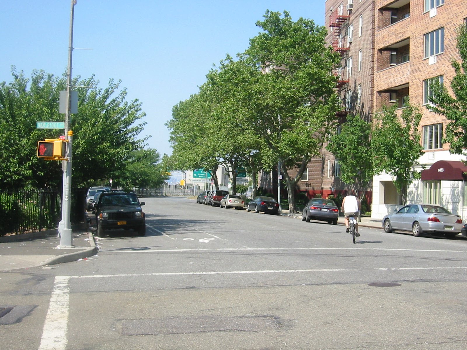
At the intersection of Shore and Bay Ridge Avenue, it was interesting to see how bicycle riders were coming to and from the 69th Street Pier.

This rider was coming from the east, down the hill of Bay Ridge Avenue.

A rider going east away from the pier, crossing Shore Road and headed up the hill on Bay Ridge Avenue. I saw 3 others going the same way a few minutes later.
This rider turned left from the pier and went north one block along Shore Road to Owl's Head Park.
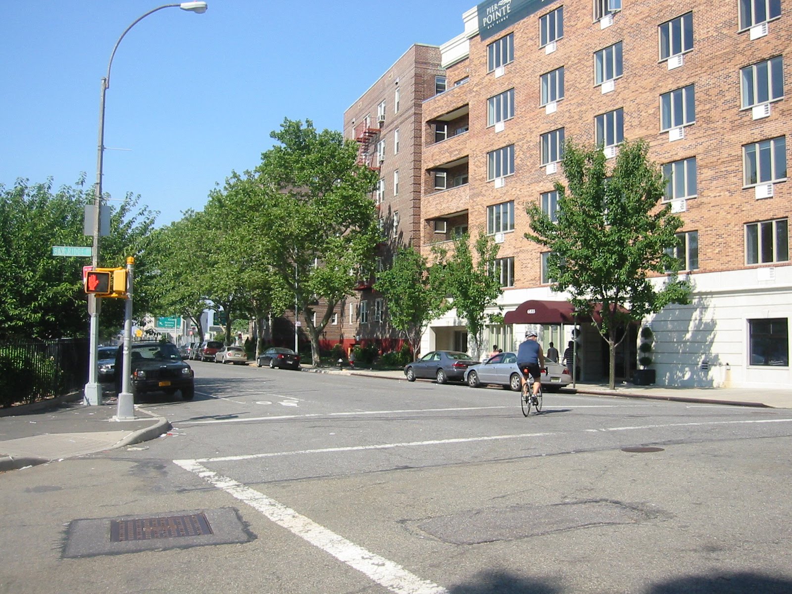
Another rider going north towards Owl's Head Park. This was very common. This rider and 2 others were seen making this turn then right onto the 68th Street bicycle lane. 68th Street is actually one-way (westbound) in the opposite direction these bicyclists were traveling (eastbound along 68th).

OK, so let's follow this rider and go south along Shore Road! He just turned right from the pier, headed south and passing a bus stop with a concrete stopping pad.

The Shore Road bicycle lane passes Ft Hamilton High School. This woman was going south.

Another view from the same location with a bicycle rider going north along the southbound lane. This is common along Shore Road because there is no northbound cycling lane between 69th Street and Oliver Street.

Onward and south along Shore Road!

At Oliver Street, a few features occur. The Shore Road southbound bicycle lane continues as usual. A northbound lane also appears. This is actually the end of the northbound lane which then turns east to Oliver Street (left side of photo).

Coming to 3rd Avenue (feeding in from the left side of photo) there is a lot of activity. All the traffic of 3rd Avenue is connecting to Shore Road. The area farther ahead is between 3rd and 4th Avenue and is a significant terminus for both local and express buses on both sides of Shore Road. Bus routes along Shore Road, 3rd and 4th Avenue terminate and layover here. The bicycle lane is on both sides of the Shore Road, with northbound and southbound lanes. Bus stops run along the entire length of Shore Road, with stops every few blocks to serve these local and express routes. Along Shore Road, some of the stops have the concrete stopping pads, some are just asphalt. However, the surfaces are just fine to ride and I've never seen a conflict between the buses and cyclists. In my experience, the bus drivers are very courteous and respectful to the bicycle lanes - Brooklyn MTA drivers are the best!

Finally, we reach the end of Shore Road at 4th Avenue. Bicyclists usually turn right from here, taking a street-level path across a vehicle approach to the Belt Parkway and continuing to a bridge over the parkway to the water. The car turning right is going to the Belt Parkway. In the background, the row of pylons is marking the lane for cars coming off the Belt Parkway.

Bicyclists riding away from the harbor and into the neighborhood have a few choices....

If they follow the on-street bicycle lane, they would ride north on the bicycle lane of Shore Road.

But a surprising number of riders cross Shore Road and continue up 4th Avenue where there is no bicycle lane and a lot of vehicle traffic.
On a closing note, all of these photos were made on the afternoon of July 5 between 4pm and 5pm, a scorching hot day at 95+degrees F. Despite the heat, plenty of bicycles were using the Sore Road Bicycle lane!
4 comments:
the Shore Road bike lane has been around quite a long time. The lane is good and helpful but it does have some constant issues. As you note you have salmons riding in the wrong direction, which I am sorry is dangerous and I don't understand. There is room on the other side, or you can use the bike lane on Colonial going north a few blocks north.
Also, you often have runners in the bike lane, especially in the morning and evening and these runners often run in the wrong direction and do not get out of the way.
That said, it is a great bike lane.
Suggestion, how about some posts on where there should be new bike lanes, especially 75th Street running all the way out until ends past Bay PArkway.
What's the best way to get from the Shore road bike path to Prospect Park?
Hmmm... following bike paths would take you from Owls Head PArk over to 7th Ave, around the est side of Greenwood Cemetery and towards Prospect Park.
However, the more direct route would be to follow 2nd Ave to around the 40s, jog over to 3rd Ave until the 30s, then over to 5th Ave along the west side of Greenwood Cemetery and up the hill to Prospect Park.
http://maps.google.com/maps?f=d&source=s_d&saddr=Owls+Head+Park,+New+York,+NY&daddr=Prospect+Park,+New+York,+NY&geocode=FSYfbAIdqVuW-yE3w7LzQQRQcQ%3BFS9ybAIdSlWX-ylDBGiHEFvCiTGYet8AxveLFw&hl=en&mra=ltm&dirflg=b&sll=40.654857,-73.99395&sspn=0.048511,0.093813&ie=UTF8&ll=40.655704,-73.99395&spn=0.04851,0.093813&t=h&z=14&lci=bike
happy to glade in those pictures i was visit last week. Very best informative Articles with beautiful bay ridge road mages. But if some one Blocked Driveway in Bay Ridge i have just call or inform to Blocked Driveway Towing Bay Ridge and feel free
Post a Comment